This is the Metadyne Website
The Milestones and Mileposts of Greater London

London Milestones and Mileposts
Amongst the items that have survived along the urban streetscape of London are included the odd milestone and its often slightly newer counterpart the metal milepost.
Mileposts were provided along many of London's main roads but the motorization of traffic and explosion of road-signage made them less useful and they ceased to be maintained and when damaged or in the way were often removed. In consequence, the fortunate survivors are comparatively rare beasts and there is some effort being made to preserve them.
Quite why it appears that a much larger proportion of mileposts have survived than the once far more numerous parish boundary marks is a mystery. Milestones tend to be larger and situated in prominent positions, which probably has something to do with it. They are also attractive and inherently photogenic, which probably helps mark them out as items of interest.
The ones on this page are roughly grouped by route, but more will be added as they are encountered. At present the focus is on north-west London, but other areas will follow.
More about 'Waymarks'
A waymark is a mark provided to aid those using highways, to provide directional or other useful information. Milestones are waymarks and indicate distances, and sometimes the name of the locality. Distances were important for identifying where one was and how far away the next town (or destination town) was. It was also useful to prove distances for those people charging by distance, for example coach operators, the postal authorities and carriers. Waymarks, by definition, are to be found by the road and though they might bear a parish name are not in any sense boundary marks and must not be confused with them. Where mileposts are angled towards the road, generally the names found facing the approaching traveller is that of the next the next town. (The names on boundary marks are, on the other hand, invariably local and usually face into their own parish, so are not useful as waymarks, even when they are at the roadside - which most are not).
The loss of milestones is regrettable. It might be noted it is, and always has been, an offence to pull down or interfere with milestones lawfully placed (Highways Act 1980 S131 covers it now).
Quick Links:
Contents
The milestones that follow have been grouped as follows:
- North West London
- South West London
Others will follow in due course.
Within these groupings milestones are shown in increasing order of mileage from central London in groups based on the point of origin of the mileage readings, for example roads starting at Marble Arch.
Milestones are then placed into subgroups based on individual roads, for example, the Bath Road or the Watford Road. Generally speaking the road order works anti-clockwise from the Great North Road.
Assembling them in this way means that the coherence of a group of stones is clearer as stones along individual routes are usually of like type. When the style of stones alters part way along a route, the change becomes obvious and invites explanation. In addition, where stones are unreadable, the layout can nevertheless be inferred from its neighbours.
It also makes it easier for people looking for stones today to follow and identify them
Explanation
Where possible each road is set out with the following supplementary material
- Measuring point
- Table indicating for expected mileage whether stone still exists or has been lost
- Additional explanatory matter about that road including (where possible) an extract from a 19th century roadbook noting the places along that road and mileages.
- Where possible, the locations of lost stones are then listed.
It should be noted that for milestone purposes the roads set out here may not correspond to modern expectations. For example, milestones from Marble Arch run along what we would today call the Edgware Road. For milestone purposes we must be guided with what is actually marked on the stones and we discover the route is the Watford Road and only follows the old roman road to Edgware before turning off to head for Watford The roman road continues north as the St Albans Road, though still carrying on the London mileage.
Summary of London's Surviving Mile Markers in north-west London
This is a summary of surviving and destroyed London mile markers. At the moment the table deals only with those in north west London, but the list will be augmented periodically.
Measured from Hicks Hall
| Route | Measured from and to | 1 | 1½ | 2 | 2½ | 3 | 3½ | 4 | 5 | 6 | 7 | 8 | 9 | 10 | 11 | 12 | 13 | 14 | 15 | 16 | 17 |
| Gt North Rd | Hicks Hall to Barnet |
Key
Green = mark present, Red = mark gone, Yellow = no mark AND not on old maps so old
mark only conjectured, Blue = relocated, Grey = not applicable.
The numbers along the top represent the stated mileage from the London end. Hold mouse
over yellow marks for additional information.

Hicks Hall (named after Sir Baptist Hicks) was a building used by the Middlesex Justices located just north of Smithfield, more or less at the junction of St John Street and St John Lane and opened in 1611. This well-known building near the City border became the point from which mileages were measured for routes running north along St John Street and Upper Street, or what today would be known as the Great North Road. The first market town was Barnet and north of Barnet roads gradually peeled off to dozens of destinations in the north and west, all measured from Hicks Hall. The table below indicates surviving and lost marks.as far as Barnet.
In mid Victorian times there had also been mileposts based on Smithfield at Islington High Street (near White Lion Street) - 1 mile and based on the General Post Office at Holloway Road (near Jackson Road) - 3 miles and Holloway Road (near St John's Villas) - 4 miles.

This is a contemporary print of Hicks Hall, looking to the north. [Old and New
London]
A milestone at North Hill, Highgate, part of the Great North Road (one of few survivors). Almost unreadable now, it is known to have indicated London 5 miles (left, and part visible) and Barnet 6 miles (right).

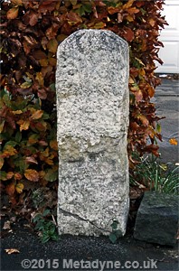
A pleasing survival is the milestone at North Finchley along a section of the Great North Road route. Post dates 1874-1894 but probably replaces something earlier.

A fair condition Great North Road milestone at north end of Pricklers Hill, near Barnet. This indicates London X miles and Barnet I Mile.
Measured from Regents Park
| Route | Measured from and to | 1 | 1½ | 2 | 2½ | 3 | 3½ | 4 | 5 | 6 | 7 | 8 | 9 | 10 | 11 | 12 | 13 | 14 | 15 | 16 | 17 |
| Finchley Rd | Regents Park to North Finchley |
Key
Green = mark present, Red = mark gone, Yellow = no mark AND not on old maps so old mark
only conjectured, Blue = relocated, Grey = not applicable. The
numbers along the top represent the stated mileage from the London end.
In 1826 the construction of a new turnpike road was authorized by the Finchley Road Act. This comprised most of Avenue Road and the so-called Finchley New Road between Swiss Cottage and Church End Finchley where it joined Hendon Lane, which was improved as far as North Finchley where it joined the Great North Road. South of Swiss Cottage another section was built linking to the north end of already-constructed Wellington Road (which was improved down to St John's Chapel). The new route was constructed to facilitate the coaching trade and avoided the steep hills either side of Hampstead as well as shortening journeys. Mileage appears to have been calculated from the North Gate of Regents Park (by Macclesfield Bridge). There was once a 1 mile post near College Crescent outside the North Star public house, a 2 mile post opposite the end of Weech Road, at where, today, Birnbeck Close lies (at 4 miles) and in Ballards Lane near Christchurch Road (at 6 miles). There was also at least one post measured from Charing Cross (at 4 miles) just north of West End Lane. As far as I can see this was the only one of these and reflected the route into Central London via Baker Street.
There is a helpful zoomable print of the route the Finchley Road was to carve through the existing topography HERE.
As road books were coming to an end at the time Finchley Road was being built, none of the ones I have include it.

This is a fine survivor of a typical milestone (though of metal) of the kind often associated with turnpike roads. This one, on the former Finchley turnpike (Finchley New Road) at Golders Green, notes the parish in which situated.

This post is in Regents Park Road near Finchley Central, along what was once the Finchley New Road (built 1826). The mileposts were probably installed by turnpike trust, but it was usual to mark the parishes in which the posts were situated.
.
.
Measured from Post Office, Holborn Bars and St Giles Pound
Routes that proceeded along the Tottenham Court Road were measured from St Giles Pound, located near St Giles church in St Giles High Street. The Pound was removed in 1765, presumably being felt unnecessary in what was now a built up area. The parish pound (where loose animals could be kept) had originally been close to the church but in 1656 it was moved to the junction of the High Street, Tyburn Road (Oxford Street) and Tottenham Court Road, where, later Meux and Company established its brewery. Since it was a well-known mark denoting the southern end of Tottenham Court Road it was a convenient place to measure from.
Holborn Bars was the location of one of several bars or gates surrounding the City of London where those who were not freemen were charged a small toll to permit entry of a cart or carriage. The location is marked today by the obelisks carrying the City dragons and for practical purposes marked the south end of Grays Inn Road, which formed one of the northern exits from London


| Route | Measured from and to | 1 | 1½ | 2 | 2½ | 3 | 3½ | 4 | 5 | 6 | 7 | 8 | 9 | 10 | 11 | 12 | 13 | 14 | 15 | 16 | 17 |
| Mill Hill Road | St Giles to Mill Hill via Camden Town | ||||||||||||||||||||
| Camden Town | Holborn Bars to Camden Town | ||||||||||||||||||||
| Highgate Rd | Camden Town to Highgate |
Key
Green = mark present, Red = mark gone, Yellow = no mark AND not on old maps so old mark
only conjectured, Blue = relocated, Grey = not applicable. The
numbers along the top represent the stated mileage from the London end. Hold mouse over
yellow marks for additional information.
There are also extant milestones measured from the Post Office at 4 miles along Haverstock Hill and 5 miles along Highgate West Hill, both overlaid on the St Giles/Holborn Bars routes. It is assumed the measurements followed Crowndale and St Pancras Roads to Holborn Bars then eastward to the City.
Milestones along the Hendon and Mill Hill route are known to have existed so long ago as 1752, when a contemporary horticulturalist who lived with a 'bow shot' of the X milestone at Mill Hill, described them as 'newly erected'. They would appear to be the same ones present today.

This very weathered stone is at north end of Grays Inn Road and 1870 mapping indicates it stated Holborn 1 mile. Marks at the top of this face are consistent with this. It is exactly a mile to Holborn. Northbound routes from both the Post Office and Holborn bars were routed this way.

Measurements from St Giles Pound only exist today from this stone, against embankment wall in Hampstead High Street, reading 3½ miles. The stone also carries the distance from Holborn Bars, which is 4 miles, via Pancras Road.

At brow of Heath we have stone indicating IV miles from St Giles Pound and no apparent reference to City alternative. This is half a mile from previous stone.

This milepost (at Church Farm Museum Hendon) is said to indicate London 5 Miles (not Roman numeral, as most others are along this section) and came from North End Road, near Golders Green. The number 5 is identifiable near top, as are the words Broad Street, which is indeed 5 miles distant (an older location for St Giles Pound). The lettering '2 Miles' are visible under that, suggesting name Hendon is present.

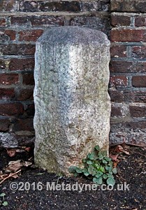
The next surviving milestone along this run is at Hendon Quadrant where, unusually, the stone has been embedded into a front wall, though it was almost certainly once free-standing. This one indicates VII miles from London

This stone is in Holders Hill near Hendon Cemetery and indicates VIII miles from London. Evidently there was no place further north whose distance was felt worth mentioning. Faded lettering on dome appears to indicate HP (Hendon Parish).
The reference to 'IX' miles is just visible on this very worn stone, which is otherwise similar (as far as can be seen) with the previous two. It is located along Bittacy Hill near Engel park. This is listed GrII, but HE gives wrong grid reference and map.

This stone is almost exactly half a mile north of the IX-mile stone and is conjectured to be a 9½-mile mark.

This miserable sunken remnant is located along The Ridgeway near the Three Hammers. It represents London X miles, but no obvious lettering is actually visible. Though still in Hendon, the style is quite different from other stones in sequence. This is listed and reputed to date to c1752.

This stone in Highwood Hill is on south side just west of Hendon Wood Lane and letters XI can be seen (XI miles). This mark is 550ft short of the correct mileage position and maps suggest correctly placed stone once in Totteridge Lane; it would appear to have been moved to the short position at some time. A benchmark is indicated on side. Stone listed GrII and description states word 'London' visible.

This stone in South Grove Highgate for many years wrongly indicated V miles from St Giles Pound until an irritated local resident corrected it. Curiously. This, and another half a mile south, are only St Giles stones along this road from London via Camden Town and Kentish Town and are probably earlier than a post office one just 400yds south.
Highgate West Hill south of Millfield Lane, the southerly of surviving St Giles Pound stones at 3½ miles, though intermediately there is a Post Office stone. Use of Arabic half with roman figures unusual

This weathered stone along Highgate West Hill indicates 5 miles to the Post Office (then in Lombard Street). Faint traces of possible date at bottom, perhaps 1811 or 1814. The route is via Kentish Town and St Pancras Road and not far from St Giles Pound stone in previous set.

Milestone along Haverstock Hill, near former Load of Hay pub. It reads 4 miles from the Post Office 45ft North [of stone], the latter suggested by worn lettering (the stone is necessarily displaced 45ft south of correct position which would otherwise be in middle of Steele's Road). Most of the Mill Hill run measures from St Giles, so why this one differs is not known. The route was probably via St Pancras Road but distance is slightly out and needs more investigation
.
.
Measured north from Marble Arch (Tyburn)
The milestones just state 'London' but the road books inform us that measurements towards the north-west originate at the Tyburn Turnpike, the junction where two Roman roads cross at what today we know as Marble Arch. The Tyburn (or Tybourne) is a river flowing southwards, one arm on the line of the Serpentine, and which gave rise to the name of the area west of Edgware Road as far as Bayswater Road. For many years a fixed gallows was located adjacent to this road junction and while these were removed in 1759 executions continued for many years using portable gallows. It appears that the space was needed for the several sets of toll gates installed at this location, together with the toll house.
It is perhaps unexpected that mileposts along the ancient Watling Street measure towards Watford rather than St Albans since this means turning off near Edgware onto a quite different road, but that is how things were arranged on the posts and in the road books. The St Albans sequence therefore begins north of Edgware, but there are no survivors in the London area.

West of Stanmore the milestone sequence continues along the road towards Pinner Green and neither maps nor the stones reference the next town in the country direction. Road books are inconsistent about where the road leads and this edition of Paterson calls it the Chesham Road (running via Rickmansworth) - it actually joins the Harrow-Rickmansworth Road at Pinner Green. Strangely, this long section of road having reached Pinner Green offers only very indirect communication with Uxbridge.
On the Chesham Road, very old maps suggest the posted route was Watling Street to Edgware then Pinner, but late eighteenth century maps indicate an alternative measured route along Harrow Road via Harrow Weald and Hatch End. During the early ninetenth century an improved route via Pinner was available, taking about a mile off the route north of Pinner Green and requiring more northerly stones to be rearranged (perhaps for the second time). Changes like this were presumably not uncommon. There had therefore been 11 and 12 mile stones in the Wealdstone area, but evidently not for very long.
| Route | Measured from and to | ½ | 1 | 1½ | 2 | 2½ | 3 | 3½ | 4 | 5 | 6 | 7 | 8 | 9 | 10 | 11 | 12 | 13 | 14 | 15 | 16 |
| Watford Rd | Marble Arch to Watford (via Edgware Rd) | ||||||||||||||||||||
| St Albans Rd | Edgware (Stonegrove) to Elstree | ||||||||||||||||||||
| Uxbridge Rd | Stanmore to Pinner Green | ||||||||||||||||||||
| Harrow Road | Marble Arch to Harrow & Rick'sworth |
Key
Green = mark present, Red = mark gone, Yellow = no mark AND not on old maps so old mark
only conjectured, Blue = relocated, Grey = not applicable. The
numbers along the top represent the stated mileage from the London end. Hold mouse over
yellow marks for additional information.
On the Watford Road there had been milestones at Crompton Street (near Paddington Canal) - 1 mile, Kilburn High Road at Springfield Road - 2 miles, Willesden Lane - 2½ miles, Shootup Hill at Christchurch Avenue - 3 miles (and inaccurately located), The Hyde at The Greenway - 7 miles, Edgware Road opposite Bacon Lane - 8 miles, Stone Grove by Orchard Drive - 9 miles, London Road east of Dennis Lane - 10 miles and The Common (north of Springfield Close) - 11 Miles. There had also been a half mile stone in Edgware Road at the end of Star Street which has survived, after an eventful retirement, and presently resides at the entrance to the Hilton London Metropole Hotel, nearly half a mile from its correct position. This is perhaps representative of stones along this road before the metal posts were introduced. Further details and photographs of this survivor may be found HERE.
On the Elstree and St Albans Road there had been milestones along Brockley Hill north of Stanmore Golf Course - 10 miles.
On the Uxbridge Road there had been milestones west of Chartley Avenue - 11 miles and in The Broadway near Grimsdyke Road - 13 miles.
Along the Harrow Road there had been milestones at Harrow Road north of Bishops Road Bridge - 1 mile; Opposite Chippenham Road - 2 miles; Kensal Green opposite Berens Road - 3 miles; High Street Harlesden opposite Furness Road - 4 miles; Craven Park, west of Park Road - 5 miles; north of River Brent by Sylvia Road - 6 miles; Wembley, near Park Lane - 7 miles; Sudbury, opposite District Road - 8 miles; Sudbury Hill by Greenford Road - 9 miles; Pinner Road east of Oxford Road - 11 miles and Pinner Road by Alandale Road - 14 miles.

This much-disturbed milestone is currently in hotel foyer in Edgware Road near Praed Street. This face reads Half a Mile From Tyburn Gate and was once located near Star Street, exactly that distance north along Edgware Road. See link in text above for more information.

This one (now the most southerly in this run) is located in Cricklewood Broadway just north of the telephone exchange. It has sunk slightly, obscuring plinth and maker's information. A little south of here the road enters Hampstead parish, which seems to have been less inclined to install mileposts.

This milepost was originally located on Edgware Road a little south of bridge over River Brent. The blank top appears once to have read Parish of Hendon (arched) and Brent Bridge (straight, beneath). Words have been chiselled off. The mark was recovered from site and now resides at Church Farm Museum. Brent Bridge was near what was later called Staples Corner. Dated 1832.

This is still located along the Edgware Road at The Hyde. It is similar to the 5/9 post but manufacturing information differs (date suggests made 1852). The simplified parish information at top appears to be presented on a separate plate.

Maps explain this stone in Uxbridge Road Stanmore denotes London 12 miles but the mark has been defaced to eliminate reference to London, and perhaps also the distance, which is certainly unreadable. Distance based on Marble Arch and Edgware.
This stone, further along Uxbridge Road, in Pinner, is also defaced and originally indicated London 14 miles. There is a suspicion this damage may have been inflicted in wartime zeal to confuse invading troops.
.
.
The much interfered-with Harrow Road has lost all but one of its mile markers, this survivor being at Harrow on the Hill. It was probably cut when school built. A fine, well preserved stone though.

This old post in Pinner Road near Headstone Lane is unfortunately fenced off but is a useful survivor. It appears to be of similar style to the next image, but reads London 12 miles. [Temp image from Streetview]

North of Harrow, on the Rickmansworth Route, this fairly unusual design is found in Pinner, near Waxwell Lane. It looks a bit like a stone but it appears to be an iron casting. Gr II listed.
This stone is very difficult to read but it is possible (with some imagination) to discern the number 15 near the top, and maps indicate it stated London 15 miles (or some vaiation on this). Marks on the side also suggest lettering, not readable though.

Near the summit of Rickmansworth Road, nearly opposite the entrance to Mount Vernon Hospital, is this surprising example, with benchmark. It is good to see Marble Arch confirmed as origin.
Measured west from Marble Arch (Tyburn)
The
Uxbridge Road has several names but the most
well known alternative is probably the Oxford
Road. Oxford was the first place served of great
importance while Uxbridge was the first market
town.
The road had many branches serving most of
Wales and much of the mid west of England and
south-central England; there
are, however, no notable branches in the London
area apart from the link west of Shepherds Bush
to the Bath Road. Unfortunately the Uxbridge
Road has been susceptible to various road
improvement schemes and most of the mile markers
have been lost.
| Route | Measured from and to | 1 | 1½ | 2 | 2½ | 3 | 3½ | 4 | 5 | 6 | 7 | 8 | 9 | 10 | 11 | 12 | 13 | 14 | 15 | 16 | 17 |
| Uxbridge Rd | Marble Arch to Uxbridge |
Key
Green = mark present, Red = mark gone, Yellow = no mark AND not on old maps so old mark
only conjectured, The numbers along
the top represent the stated mileage from
the London end.
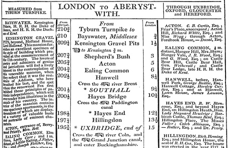
There had once been marks at the following locations. Bayswater Road near Leinster Terrace - 1 mile; Holland Park Avenue, nearly opposite Lansdowne Road - 2 miles; The Vale, by Bromyard Avenue - 4 miles; High Street Acton, opposite King Street - 5 miles (moved nearby); High Street Hanwell, at Westminster Road - 8 miles; Uxbridge Road nearly opposite Dormer's Well Lane - 9 miles; The Broadway Southall near Townsend Road - 10 miles; Uxbridge Road, at Coldharbour Lane junction - 11 miles; High Road Hayes End - 12 miles (now looped out as Park Road, near Park Lane); Uxbridge Road near Pole Hill Road - 13 miles; Hillingdon Hill near cemetery entrance - 14 miles. There had also been a 3-mile mark on branch in Goldhawk Road, east of Richford Street.

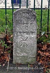
There is a very hard to read milestone (unusually) formed by a tablet sunk into front wall of White Horse pub in Uxbridge Road, Shepherds Bush. Until better image obtained, this representation is given above. The actual lettering quality is grim and has a home-made look about it.

This is a photograph of the stone, located behind glass into which moisture has condensed.

Once conspicuously located in the High Street in Acton it has been uprooted and parked outside the nearby church where it is virtually hidden from view and will not be found unless especially looked for. This may be the only surviving Acton post. Marked Barrett 1837.

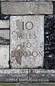
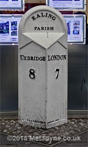
Sadly, there are few surviving mile posts along the whole of the Uxbridge Road. Two are in Ealing. and this one is alongside Ealing Common. This is dated 1832 and made by R.J and J Barrett.
The next post along, of identical date and design, is located at West Ealing. These posts look reasonably well cared for.

This iron post in Uxbridge High Street, marked only '15' is 15 miles from Marble Arch. Unusual in containing no other information and provenance unknown. Rear blank. Probably covered by Grade II* listing of surrounding building (listing entry text ignores it).
.
.
Measured west from Hyde Park Corner


The roads measured west from Hyde Park Corner are based on the trunk heading due west with many branches peeling off it, even in the London area. The way out of London was usually called the Bath Road, but both Carey's and Paterson's early nineteenth century road books give preference to the south-western variant via Staines to Exeter and Poole respectively. Paterson's 1822 edition offers the Bath Road as the 'trunk' route, and this probably reflects the much improved route created by the turnpike trusts. Prior to the turnpikes the best routes were uncertain and variable but the improvements of a small number of good routes gradually settled the matter. In London the Brentford Trust managed the road east of Cranford Bridge (near Hounslow) and the Colnbrook Trust the next section west (which probably explains the change in milestone type at Cranford).
Dealing only with Middlesex routes, the first road peeling off is the Fulham Road at Knightsbridge, taking a route to Putney Bridge (and bound for Richmond and Kingston); This spur is covered in the section (following) covering South West London. The next is beyond Brentford and serves Twickenham and Teddington. The last significant road turns south west from Hounslow and heads for Staines and beyond, for many years in the care of the Bagshot and Bedfont Trust; from this road near Bedfont an apparent route via Stanwell towards Windsor is faintly detected (but presents a number of questions). A single milestone (long gone) has been located in King's Road, but this was measured from the Post Office.
| Route | Measured from and to | 1 | 1½ | 2 | 2½ | 3 | 3½ | 4 | 5 | 6 | 7 | 8 | 9 | 10 | 11 | 12 | 13 | 14 | 15 | 16 | 17 |
| Bath Road | Hyde Park Corner to Colnbrook | ||||||||||||||||||||
| Richmond Rd | Fulham Rd ex Hyde Park Corner | ||||||||||||||||||||
| Teddington Rd | Isleworth to Teddington (ex Hyde Pk Cnr) | ||||||||||||||||||||
| Park Road | Isleworth (ex Hyde Pk Cnr) | ||||||||||||||||||||
| Staines Road | Hounslow to Staines (ex Hyde Pk Cnr) |

First survivor along the Bath Road. This surpringly big, solid, cast-metal mark in Kensington Gore is one of the largest I know of and is perhaps unique. It is dated 1911 making it implausibly recent. It's design would suggest much older and maps indicate much older marks on this site. It is perhaps a replica.

This shows the previous mark is fixed to the ground and is not attached to wall in any way (wall was built around 1930 and replaced garden wall built circa 1870). The building itself is listed but this quite separate post appears not to be listed in any way.

Near the corner of Kensington Court is this 'Barrett' metal mark, unusually displaying a half-mile interval. It is of slight interest that along the Bath Road, Hounslow was the next place felt worthy of mention.

It is great that this post in King Street has been kept, but locked behind bars in its little prison with no apparent means of cleaning or repair seems curiously mean treatment for this aged public servant. One of few painted in 'reversed' colours.

This one along Bath Road east of Isleworth Station reads London 8, Hounslow 2 and is the first in a valuable sequence.

This one is on Bath Road near Heston and reads London 9 and Hounslow 1. An R.J. and J. Barrett post dated 1834.

Milestone on Bath Road west of Hounslow, an unusual and large stone tablet in wall. The top reads London 10 Miles, Colnbrook 7 Miles. It is noteworthy that Houslow was a place, but Heston was the parish.

Milestone on Bath Road near Hounslow. The top reads London 12, the right hand face reads Hounslow 2 miles and the left hand face Colnbrook 5. The back looks as though it bears traces of lettering, none readable.

This one along Bath Road at Harlington Corner and reads London 13, Colnbrook 4 and Hounslow 3.

This one is near west end of airport Newport Road.and reads London 14, Colnbrook 3 and Hounslow 4.
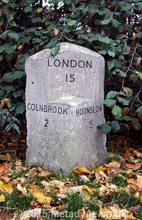
Milestone along the Bath Road, near Longford, indicating that Colnbrook was the next important place beyond Hounslow. London 15, Hounslow 5 and Colnbrook 2.

Milestone on old Bath Road east of Colnbrook near M25. Appears to read London 16, Hounslow 6, Colnbrook 1. This stone has been resited.

The stone in previous image is located on the diverted Bath Road where it now crosses the M25 and Wyrardisbury River. The old road, slightly to the south, crossed the river at the Mad Bridge, derelict but amazingly still in situ. The milestone had been located at right hand end of the bridge, on south side, and it is noteworthy somebody felt it worthwhile to recover it and put it alongside diverted road.

Milestone on Bath Road in Colnbrook village. Appears to read London 17, Hounslow 7, Maidenhead 9. Remnants of benchmark at bottom left.

There is only one post left along the old Knightsbridge - Richmond Road (Fulham Road), this one near Landridge Road. One of very few painted like this. London (Hyde Park Corner) 3½, Richmond 4½. One of very few painted in reversed colours.

The Twickenham and Teddington Roads diverge at Isleworth but still measure from Hyde Park, this one 8 miles distant. This suberb Isleworth stone along Park Road is an unexpected find on what is hardly a main road. The stone is about 8-ins thick.

Another well-preserved stone, also at 8 miles, in nearby Twickenham Road which remains a main thoroughfare. Though superficially similar, it is not quite identical in style to that in Park Road.

The next stone along is of similar style and inspection of rear shows it blank. Located today on green verge it has had an eventful life and suffered some damage on the front and there is a chunk missing on rear. Other stones along this road are now gone.

Staines Road near Hounslow, the only surviving metal post along this section of road. The words Heston Parish appear under the London distance, 11 Miles. This needs to see business end of a paintbrush. Listed Gr II.

Staines Road at East Bedfont, first of a series of large stones. XII Miles from Hyde Park Corner) and dated 1743, as some others on this road. Side faces blank, rear not seen. Recently painted white. Listed Gr II.

This stone on Staines Road by Bedfont Library indicates Hyde Park Corner 13 miles on its roadside face, but see next image. For some reason this face has also been cut, with no date and Arabic figures. Listed Gr II.
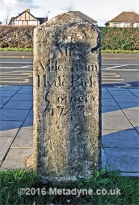
This is the back of the previous stone, showing Hyde Park Corner XIII miles and dated 1743. The suspicion is that this was once the roadside face. Why this still-legible message was recut in different form on other side is unknown. The flank sides are blank.

The next stone along Staines Road is near Orchard Cafe and indicates Hyde Park Corner IV Miles. Odd lettering at top suggests stone may have been recut at some point and the panel cut out to provide a clear ground on a worn stone. Rear appears blank but not conclusively so.
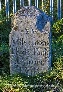
London Road near Staines, next to reservoir, has the last stone in this set. This one indicates XV miles from Hyde Park Corner and is another one dated 1743. There are suggestions of marks on rear indicating 15 in Arabic figures, but too weathered for certainty. Moved slightly when road widened. Listed Gr II.


This London 15 mile stone at Stanwell is neither on a main road nor in the same position shown on old maps (shifting prior to 1950). Under the London distance (perhaps recut at sometime) another word 'Miles' is visible and fragments suggest Windsor 7 Miles, though road books do not acknowledge this route. The distance 15 is two greater as crow flies from 13 mile post on Staines Road, but bafflingly the actual route by road between MPs is much greater. The MS1833 on side is probably part of St MS (St Mary Stanwell). There is some evidence of lettering on east face, impossible to make out.
.
Measured west from Kingston Bridge
On this 'crossroad' surviving milestones are purported to measure from Kingston Bridge and Staines and are located 2/7 miles, 3/6, 4/5 and 7/1 miles. The route near the Palace appears to use the path cutting across The Green. The route passes along Hampton Court Road, Upper Sunbury Road, Staines Road and Kingston Road.
| Route | Measured from and to | 1 | 2 | 3 | 4 | 5 | 6 | 7 | 8 |
| Staines Road | Kingston and Staines |
Key
Green = mark present, Red = mark gone, Yellow = no mark AND not on old maps so old
mark only conjectured, Blue = relocated, Grey = not applicable.
The numbers along the top represent the stated mileage from the London end. Hold mouse
over yellow marks for additional information.

A good sequence of surviving milestones based on Kingston Bridge starts in Hampton Court Road. This face shows Kingston II miles and the nearest bridge VI furlongs or ¾ mile.

This is the east face of same stone showing Sunbury II, Staines VII and Windsor XIII miles. The front and rear faces are blank. There is a benchmark stud and OS arrow on the top.

This is the east face of next stone of probably similar design with word Sunbury at top, presumably indicating I mile. Other measurements are Staines VI and Kingston Bridge III. Front face apparently blank.

This is the front face of next stone in Staines Road East. It appears to read Sunbury Parish at top. Kingston Bridge IV Miles and Staines V miles.
This is the last surviving stone along this route in Kingston Road near Warwick Avenue and bears benchmark. It ought to indicate Kingston Bridge VIII Miles and Staines I mile but weathered lettering makes reading it very difficult.

Side view (looking west) of previous stone. There is faint evidence of lettering but it is impossible to make out.
Summary of London's Surviving Mile Markers in south-west London
This is a summary of surviving and destroyed London mile markers in south west London. This deals with mile markers south of the Thames and in some instances short sections of road north of the Thames that are parts of south London roads.This section is very much under construction and will be augmented periodically.
Richmond Bridge Obelisk
This obelisk, about 15ft high, is located in Bridge Street, Richmond, but has been relocated from its original position slightly further north. Its southern face is inscribed ‘The . first stone . of . this Bridge . was laid . 23rd August . 1774 . and finished . December 1777’.
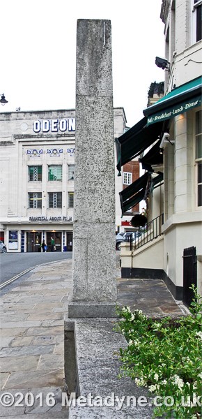

The distances on the east face read:
To . HYDE PARK . CORNER . VIII Miles . three . Quarters . WESTMINSTER . Bridge .
X Miles . To LONDON . Bridge . XI Miles . One quarter
The distances on the north face read:
to . HAMPTON . IIII Miles . SUNBURY . VI
Miles . One quarter . WALTON . VII Miles . three . quarters . CHERTSEY . X Miles . and half .
HOUNSLOW . III Miles . three . Quarters . STAINES . IX Miles . and half . COLNBROOK . X Miles . three Quarters .
WINDSOR . XV Miles . three . Quarters
At the bottom of the north face a separate part reads:
ANY PERSON WHO SHALL . WILFULLY DEFACE OR . DAMAGE THIS
OBELISK . WILL BE PROSECUTED . BY ORDER OF THE . COMMISSIONERS
South-West London Milestones
South of the Thames the same neat measuring system of the radial roads from a small number of central origins, as seen north of the River, is much harder to discern and the surviving evidence is confusing. This will be reviewed as research proceeds but for the moment the the routes shown in the old road books have basically been followed irrespective of the claimed origins. So many roads include several origins, often half or a whole mile different from each other so the coloured table system of indicating surviving and missing stones has not for the moment been followed. Instead a written list is given which indicates what is understood to be going on, with photos of surviving stones at the end of each 'road' section.
Kingston Road (Portsmouth Road via Clapham to Kingston and branches)
The Portsmouth Road was the key road in this sector of London, measured originally from The Stones in Southwark, and later from The Standard in Cornhill (a water pump at junction with Gracechurch Street, though removed in 1674). The measuring point later bec The route passed across bleak Putney Heath and missed the more welcoming town of Richmond which was served by a branch Road from Wandsworth. The Richmond route also led to Kingston but was longer than the direct road across Putney Heath. The opening of Putney Bridge offered a new route from West London, branching off the Great West Road and coming from Fulham, Putney Bridge and Lower Richmond Road to join the Wandsworth-Richmond route, the milestones showing distances to Cornhill and Hyde Park Corner. Putney Hill allso made the connection between the main Portsmouth Road over Putney Heath and the Hyde Park Corner route (it appears that to the south west of this junction Hyde Park Corner mileages were preferred to those directly to the City via Wandsworth).
KEY: Blue: Stone still in place. Black: Gone, but shown on old mapping. Red: Conjectured (not on mapping)
- Newington Butts, N end E side next to Short Street (maps do not indicate distance but it is exactly 1½ miles from The Standard Cornhill).
- Kennington Park Road, W side opposite Kennington station
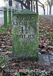
- Kennington Park Road, W side 5 buildings N of Harleyford Street Whitehall 2, Royal Exchange 2½
- Clapham Road (Stockwell), W side 2 buildings south of Albert Square. Whitehall 2½, Royal Exchange 3
- Clapham Road, W side opposite Grantham Road. Whitehall 3, Royal Exchange 3½
- High Street, Clapham., W side opposite Aristotle Road, Whitehall 3½, Royal Exchange 4.
- Clapham Common North Side, east end, 150 yards west of junction with South Side. Conjectured Royal Exchange 4½ miles.
- Clapham Common North Side, S side, Opposite Victoria Rise (was Road). (Westminster 3½, Cornhill 5)
- Clapham Common North Side, between Tregarvon Road and Jedbergh Street. Conjectured Royal Exchange 5 miles. Note that this location is only 433 yards west of the stone marked Cornhill 5 miles.
- Wandsworth Common North Side at junction with Spencer Road. Conjectured Royal Exchange 6 miles.
- East Hill, just east of North Street (now Fairfield St) / St Annes Hill. Royal Exchange 6½ Whitehall 6. (This is 200 yards west of expected position, based on previous locations.
- [Wandsworth] West Hill, outside library east of Santos Road. Royal Exchange 7 miles, Whitehall 6½ miles.
- West Hill just east of Tibbetts Corner. Royal Exchange 8 miles, Whitehall 7½ miles.
- Kingston Road, Just west of Alton Road (Old Route), S Side. Whitehall 8 ½, Royal Exchange 9. [By Sun Ent)
- Kingston Vale, just west of Robin Hood Lane, S Side. Whitehall 9 ½, Royal Exchange 10.
- Kingston Hill, 40 yds N of Fairlawn Close. SE side. Whitehall 10½, Royal Exchange 11. [In Hedge]
- London Road, Between Coombe Lane and Station Road, NW side. Whitehall 11½. [Logically RE 12]. By what was later rail bridge
- Portsmouth Road (with High Street) at corner South Lane (E side), Hyde Pk Cnr 10, Portsmouth 59
- Portsmouth Road just east of what today is Simpson Way(S side), Kingston 1, Esher 2¾. Replaced a few yards N by new stone marked Hyde Park Corner 11, Portsmouth 58

Milestone in Clapham Road north of Stockwell
near Albert Square. Front reads Royal Exchange 3 Miles. Sides both read Whitehall
2½ Miles. Rear blank. Benchmark added.
Milestone along Clapham Common North Side opposite Victoria Rise. This face has much lettering but very difficult to interpret. Maps indicate Cornhill 5 and Westminster 3½ miles.

This milestone in West Hill Wandsworth (though it is temporarily obscured) outside what had been a library.
Shows Whitehall 6½ on one face, Royal Exchange 7 on another. Listed structure.
Temp image from Geograph. Creative
Commons Licence. Image Paul Farmer.

This milestone is in Kingston Road (south side) west of Alton Road and is partly obscured by subway railing.
Just visible are numbers 8½. Shows Whitehall 8½ and Royal Exchange 9.
Temp image from Google Streetview.

The next milestone is in Kingston Hill on SE side, 40yds N of Fairlawn Close. It is embedded in hedge
and is often very difficult to find. Shows Whitehall 10½, Royal Exchange 11 miles.
Temp image from Google Streetview.
.
.
.
London to Richmond via Clapham Common and Wandsworth
The route from the City of London to Richmond shares its initial portion with the Portsmouth Road, described above. It diverges towards the western end of Wandworth (to the west of MP Royal Exchange 7 miles) and follows the Upper Richmond Road. The route then continues via Petersham and Ham to Kingston, where several routes converge.
KEY: Blue: Stone still in place. Black: Gone, but shown on old mapping. Red: Conjectured (not on mapping)
- Upper Richmond Road, west of Putney High Street at junction with Charlwood Road. 1868 mapping shows mile post (MP) stating The Standard Cornhill 8 miles and Westminster Bridge 6¾ miles
- Upper Richmond Road, junction with Rocks Lane. Marked on 1896 mapping without information. Stone reads 9 Miles from The Standard in Cornhill, 5¾ miles from Hyde Park Corner and 7¾ miles from Hampton Court.
- Upper Richmond Road, junction with Sheen Lane. Stone indicates 10 miles Cornhill (The Standard), 6¾ Hyde Pk Corner,and 8¾ to Westminster Bridge.
- Sheen Road at Manor Road /Queens Road. Conjectured this would be 11 miles to Cornhill, 7¾ to Hyde Park Corner and 9¾ to Westminster Bridge.

A pleasing Milestone along Upper Richmond Road (near Rocks Lane). This face states it is VII Miles 3 Quarters to Hampton Court. Another states V Miles 3 Quarters From Hyde Park Corner. Two faces state IX Miles From the Standard, at least one (with a crudely added benchmark) adding 'in Cornhill'. The opposite face may include this but is too weathered.

The next milestone along this section is at Sheen Lane. These two faces indicate X Miles From the Standard in Cornhill 1751 and VI Miles 3 Quarters From Hyde Park Corner. Another face states it is VIII Miles 3 Quarters to Westminster Bridge. Last face repeats The Standard. One face bears benchmark.
.
.
London to Richmond via Wandsworth Road
The existance of a string of milestones, either real ones or on old maps, provides evidence of an alternative route out of London along Wandsworth Road, taking a more northerly course than the route via Clapham. At the London end the route appears to start at Westminster Bridge, following Westminster Bridge Road, Kennington Road, Kennington Lane, Wandsworth Road, Lavender Hill and joining the Clapham route at East Hill, Battersea. Milestones along this section are measured from Whitehall and Royal Exchange, the route to the latter being made along Kennington Lane until its junction with the Clapham Road route, already described.
The measuring (zero) point called Whitehall appears to be its northern end opposite Whitehall Place (beyond here the road was called Charing Cross). Measurements to Whitehall are therefore a little over half a mile longer than those to Westminster Bridge.
- At junction of Kennington Lane and Kennington Road. Maps denote milepost from Westminster Bridge 1 mile. Measuring this on the ground indicates zero point at south end of the bridge structure (ie slightly inshore from River).
- There is a milespost in Kennington Lane along the City leg (at what was Mansion House Street, between Kennington Road and Clapham Road) stating Cornhill 2, London Bridge 1½ miles.
- Wandsworth Road, just north of junction with former Nine Elms Lane. Cornhill 3, Westminster Bridge 1¾ (this is in red as it is not shown on OS mapping, but it is shown on Horwoods 1795 map).
- Wandsworth Road, opposite former Devonshire (later Allen Edwards) Road (NE of Cowthorpe Road). Mileage is Royal Exchange 3½ miles, Whitehall 3 miles.
- Wandsworth Road, East of Pensbury Street,just south of Albion Road. Mileage is Royal Exchange 4 miles, Whitehall 3½ miles. 1948 mapping notes it is defaced. This is listed and claimed to be outside 372. On inspection it is clear that it has been moved a few yards west to avoid a new pedestrian crossing. List entry incorrectly states Westminster 2¼ miles.
- Battersea, Lavender Hill by Acanthus Road. Royal Exchange 5 miles, Whitehall 4½ miles.
- Battersea, St Johns Hill, just west of what today is Haydon Way. Royal Exchange 6 miles, Whitehall 5½ miles.
- (Beyond here road merges with route from Clapham)

Wandsworth Road, East of Pensbury Street. Royal Exchange 4 is just visible.
Temp image from Streetview.
.
.
.
London to Richmond Via Fulham
This route better served the exit from west London and became available when Putney (originally Fulham) Bridge opened. The route follows the Bath Road exit from London along Piccadilly and Knightsbridge, but then turns south-west following Brompton Road and Fulham Road, crossing the Thames at Putney Bridge. Immediately south of the River the route turns west, along Lower Richmond Road (originally Windsor Street) and Queens Ride. From that point it joins the Upper Richmond Road to the Talbot at Richmond (and thence, according to Paterson's Roads, to Kingston via Petersham and Ham). There are a few remaining mileposts along the first part of this route, but along the Upper Richmond Road Hyde Park Corner mileages are included on the posts already described. No milestones appear to have survived along the Richmond-Kingston section.
KEY: Blue: Stone still in place. Black: Gone, but shown on old mapping. Red: Conjectured (not on mapping)
- Fulham Road, at junction with Egerton Gardens (Sth Kensington). London (Hyde Park Corner) 1 mile. Fulham 2½ miles
- Fulham Road, at junction with (Old) Church Street and Neville Terrace. London (Hyde Park Corner) 1½ miles. Fulham 2 miles
- Fulham Road, between Victoria Road and Edith Grove. London (Hyde Park Corner) 2 miles. Fulham 1½ miles
- Fulham Road, by Brittania Road (Walham Green). London (Hyde Park Corner) 2½ miles. Fulham 1 mile
- Fulham Road, east of Parsons Green Lane (Parsons Green). London (Hyde Park Corner) 3 miles. Fulham ½ mile
- Fulham Road, near (south-west of) Landridge Road.. London (Hyde Park Corner) 3½ miles, Richmond 4½ miles
- Fulham (later Putney) Bridge, slightly south of half-way point. London (Hyde Park Corner) 4 miles, Richmond 4 miles
- Lower Richmond Road, slightly east of junction with Queens Ride Hyde Park Corner V miles. It should be noted that measurements show this is actually about a quarter mile short of 5 miles, perhaps caused by over-exuberant rounding.
There is only one post left along the old Knightsbridge - Richmond Road (Fulham Road), this one near Landridge Road. One of very few painted like this. London (Hyde Park Corner) 3½, Richmond 4½. One of very few painted in reversed colours.

The first surviving milestone west of Putney Bridge is along Lower Richmond Road near junction with Queen's Ride. All four faces are identically marked (which is unusual). The information is that the stone is that it is V Miles to Hyde Park Corner. Marked on old OS maps but unusually without disclosing mileage. Based on the Fulham post, this one is 4.71 miles from London and there seems to have been some fairly generous rounding irregularity somewhere. (Courtesy John Liffen)
.
.
Hammersmith to Richmond
This route leads from the Bath Road at Hammersmith via Castlenau and Rocks Lane to the Upper Richmond Road, joining the direct routes from London to Richmond.
- Bridge Road (Hammersmith) at Church Lane (later Sussex Place). Hyde Park Corner 3½ (presumably via Bath Road), Richmond 4¼, and the 1871 map also shows Hampton Court 9, Kingston 7½
- Castlenau, opposite Lonsdale Road. Hyde Park Corner 3 7/8 , Richmond 3 7/8, (measurements in eighths is very unusual).
- Rocks Lane, at south end of railway bridge approach. Hyde Park Corner 5½, Kingston 5½ Richmond 3½.

Rocks Lane at south end of bridge approach. A blinded milepost where parish name and distances removed. It was probably headed Barnes Parish.
.
.
.
Kew to Richmond
This short section forms one of the branches of the Great West Road, from which it diverts at Kew Bridge and the stones therefore measure from Hyde Park Corner.
KEY: Blue: Stone still in place. Black: Gone, but shown on old mapping. Red: Conjectured (not on mapping)
- Kew Road, south of Holmesdale Road at kerb near wall of Kew Gardens. Hyde Park Corner 7 miles.
- Kew Road, south of Twickenham Road opposite Hyde Park Corner VIII miles.

This example is particularly badly weathered and is located in Kew Road. Maps indicate it stated Hyde Park Corner 7 miles, and the number 7 is visible in tablet near bottom.

This is the next in the Kew Road series, near Richmond station, and indicates Hyde Park Corner VIII miles. The flanks appear blank but there is lettering on rear (obscured by wall).
.
.
Brighton Road (via Clapham, Mitcham and Sutton)
KEY: Blue: Stone still in place. Black: Gone, but shown on old mapping. Red: Conjectured (not on mapping)
This leg of the Brighton Road shares the Portsmouth Road to north end of Clapham Common. See Portsmouth Road for detail
- Clapham Common South Side, south of Crescent Lane (NW side). Whitehall 4, Royal Exchange 4½.
- Clapham Common South Side, nearly opposite Cavendish Road (south of road junction) (NW side). Whitehall 4½, Royal Exchange 5.
- Balham Road, opposite Balham New Road (west side, outside 64 - now 54 Balham High Rd), Whitehall 5, Royal Exchange 5½.
- Balham Road, S of Elmfield Road (Was west side, later east side). Royal Exchange 6
- Upper Tooting Road, opposite Foulser Road. East side. Whitehall 6, Royal Exchange 6½
- High Street, Tooting, north of Mitcham Rd, Outside (now) 33-37 Tooting High St. Royal Exchange 7.[Missing as early as 1869-82 OS mapping.]
- London Road, Mitcham, south of Crusoe Rd, west side, outside 102. Royal Exchange 8, Whitehall 7½.
- London Road, Mitcham, at corner with Lower Green West, Royal Exchange 9, Whitehall 8½. 16yds south of where expected.
- Bishopsford Road, north of Green Wrythe Lane and Olverston Walk. SE side, outside 131. Royal Exchange 10, Whitehall 9½.
- Rose Hill, south of Rosehill Park West. East side alongside recreation ground. Opposite No 96.Royal Exchange 11, Whitehall 10½.
- High Street, Sutton, west side, opposite Benhill Road. Royal Exchange 12, Whitehall 11½.
- Brighton Road, south of Egmont Road, west side, outside 106. Cornhill 13, Westminster Bridge 12. (Only ½ mile from previous)
- Brighton Road, Banstead Downs, 40 yds N of Burdon Lane, West side. London 13⅜, Brighton 38⅝, This post 45 yds south of Royal Exchange 14m position.

Clapham Common South Side near Crescent Road, a superb survivor. This face Whitehall 4 miles
This is a side view (both sides similar) showing 4½ miles to Royal Exchange. Also excellent condition. Rear blank.

This stone on Clapham Common is nearly opposite Cavendish Road and shows Royal Exchange 5 miles. Flanks indicate Whitehall 4½ miles. Interesting that labels are at right angles to display on previous stone.

London Road, Mitcham, Figges Marsh (west side) south of Crusoe Road. Maps indicate face display 8 Miles from the Royal Exchange and 7 Miles from Whitehall, but stone very weathered. Benchmark visible.

London Road, Mitcham, north end of Cricket Green. Displays 9 Miles from the Royal Exchange (front) and 8 Miles from Whitehall (flanks). Rear blank.

Rose Hill (St Helier), south of Rosehill Park West. East side alongside recreation ground. Opposite No 96. Displays Royal Exchange 11, Whitehall 10 (maps state 10½). There is illegible lettering on the flanks, including a date 1745

High Street, Sutton, displaying Whitehall 11 (maps state 11½) and Royal Exchange 12; There is illegible lettering on the flanks, rear blank. Listed and claimed to be one of 1745 set.

Brighton Road, Sutton, south of Egmont Road. Displaying 13 Miles from The Standard Cornhill and dated 1745. There is illegible lettering on the flanks. [Temp image Courtesey Bobulous via Wikimedia commons]
Brighton Road (via Brixton, Streatham and Croydon)
KEY: Blue: Stone still in place. Black: Gone, but shown on old mapping. Red: Conjectured (not on mapping)
- Kennington Road, between Chester St and Black Prince Road, W side. Horse Guards 1¼. (1865x)
- Between Black Prince Rd and Park St, Westminster Br 1.
- Kennington Road, south of Windmill Row (W side), opposite Vestry Hall. Whitehall 1½
- Brixton Road, eastern arm of triangle where Brixton Rd meets Kennington Pk Rd, (W side), Royal Exchange 2½
- Brixton Road, N of Russell St (Hillyard St) outside No 158. (W side). Whitehall 2½, Royal Exchange 3.
- Brixton Road, S of Peckford Place (W side), outside 342. Whitehall 3, Royal Exchange 3½.
- Brixton Road, S of Coldharbour Lane junction (W side). Whitehall 3½, Royal Exchange 4. (Moved to Windrush Sq opposite).
- Brixton Hill, N of Cornwall Road (Blenheim Gardens). W side outside 108. Whitehall 4, Royal Exchange 4½.
- Brixton Hill, N of Redford Walk, W side outside No 256. Whitehall 4½, Royal Exchange 5.
- Streatham Hill, N of Barrhill Rd, W side by Streatham Hill Theatre, Whitehall 5, Royal Exchange 5½.
- Streatham Hill, Opposite Woodbourne Ave, E side. Whitehall 5½, Royal Exchange 6. [Moved slightly south]
- Streatham High Road, just S of Stn approach W side. Outside 350. Whitehall 6, Royal Exchange 6½.
- Streatham High Road, opposite Factory Square (N of Voss Court), E side outside 275. Whitehall 6½, Royal Exchange 7.
- London Road, Norbury, South of Hermitage Bridge, W side outside 1593. Whitehall 7, Royal Exchange 7½.
- London Road, Norbury, N of Beatrice Ave, W side outside 1297. Whitehall 7½, Royal Exchange 8.
- London Road, Norbury, N of Winterbourne Rd, W side. Whitehall 8, Royal Exchange 8½.
- London Road, Norbury, S of Whitehall Road, W side. Outside 657. Whitehall 8½, Royal Exchange 9.
- London Road, Corner Broad Green Avenue, E side. Whitehall 9, Royal Exchange 9½.
- London Road, N of Mead Place, W side by No 61. Royal Exchange 10. [This stone disappeared from mapping by 1898 but the measurements correspond with the stone recovered from somewhere and now located in Park Hill Park. It would be good to tie these up positively]
- High Street (Croydon), N of Katherine St, By No 32. Royal Exchange 10½ [Missing 1869-82.]
- South End, N of Southbridge Road, nearly opposite Dering Road E side by 61/63. Whitehall 10½, Royal Exchange 11.
- Brighton Road, between the two limbs of Haling Road outside or opposite 111-113. Royal Exchange 11½ [Missing 1869-82.]
- Brighton Road, opposite Wyche Grove. W side. Westminster Bridge 11, Royal Exchange 12.
- Brighton Road, in forecourt of Cottage Hospital Purley. W side. Westminster Bridge 12, Standard Cornhill 13.
- Brighton Road, S of Milestone Drive. E side. Westminster Bridge 13, Brighton 38½.
- Brighton Road, Outside Coulsdon South station, W side by bridge. Westminster Bridge 14, Brighton 37½.

Brixton Hill (Windrush
Square) moved from west side of road. Other
face says Whitehall 3½.
Temp image from Wikimedia Commons. Creative
Commons Licence. Image Chris MCKenna.

Streatham Hill, Opposite Woodbourne Ave.
Whitehall 5½, Royal Exchange 6. Stone appears to
have been moved slightly south.
Temporary image from Streetview.

This relocated milestone is in Park Hill Park (Croydon) and reads Royal Exchange 10 miles on face and Whitehall 9½ miles on side. This might be the stone from London Road (Mead Place).

This is one of the side faces where 9½ can be made out. Unfortunately Croydon Council has not placed any inscription here indicating how and why stone was moved.

In Brighton Road, outside Purley Memorial Hospital, is Westminster Bridge XII (one face) and Cornhill XIII (on another). This stone clearly dated 1743.

Brighton Road, Coulsdon, south of Milestone Drive. Westminster Bridge XIII miles and Brighton (below road surface) 38½ Miles. The same messages are also presented on the other two visible faces.

The next stone is outside Coulsdon South station and also has the same message on at least three faces. This one is XIV miles from Westminster Bridge (and 37½ miles from Brighton).
Other South London Milestones

Whilst looking (without success) for a boundary mark I found this excellent stone milestone lurking in bushes. This one is perhaps interesting in defining a via point (via Putney Bridge)

Milestone alongside Clapham Common. Front states Royal Exchange 5 miles. Both flanks state Whitehall 4½ miles. (Courtesy Doug Rose)

Ewell Road at Junction with Tolworth Broadway. Main face indicates Ewell 3 Miles. Right hand face reads Epsom 5 miles.

Located in Kingston in Surbiton Road at junction with Portsmouth Road. Letters IIII Miles visible but rest weathered. Maps suggest it read 4¾ miles to Ewell.

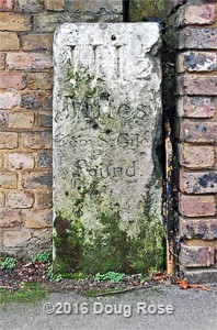
Hook Road, Chessington North, outside No 398, partly blocking front path. This broken stone appears to be of same type as next one north. Indicates Surbiton 1 mile, Kingston 3 miles, [Leatherhead] 5 Miles and Dorking 10 Miles.

Hook Road Surbiton, outside No 82.This complex shape indicates Surbiton 1 mile, Kingston 2 miles, Leatherhead 6 Miles and Dorking 11 Miles.

Close up of upper part. Dome reads Royal Exchange 15 Miles and round top band it reads Whitehall 13¼ Miles and Hyde Park 12 Miles.