This is the Metadyne Website
Lost Parish Boundary or Administrative Markers in County of London
Lost or Destroyed Parish Boundary Markers
Neither property owners nor local authorities are under any general obligation to maintain or preserve parish boundary or other administrative marks unless they are attached to a listed building (such as The Lamb public house) or happen, unusually, be be specifically listed themselves, like the ones in Carey Street.
It is true that a number of marks are identified in various audits undertaken in conservation areas, the hope being that because they have been identified some effort will be made to ensure their well-being as part of (or despite) the planning processes. Alas, I have been through a few dozen of these audits and find parish boundary marks scarcely feature and many I know to be in these areas are overlooked. I hardly dare suggest it is the obsession with buildings coupled with a general ignorance about parish boundary markers that conspire to cause these historic artefacts to be ignored quite so consistently, but whatever the reason it cannot be satisfactory. Being identified in an audit, and even being 'locally' listed, is no guarantee of a mark's future security but there is evidence that at least some of the losses stem from ignorance and that, at least, is a start.
Since the loss of a marker before my own audit captured it means, by definition, I do not have my own photograph, I have little option but to resort to using links to sites where, fortunately, someone else has done the job. That, I think, is about as far as I can go.
I hope that viewers of this site will take note from this evidence that these markers really are under threat and do anything they can to spread the word about their existence and historic significance and do anything they can to try and protect any under apparent threat, even if only notifying the local authority planning department.
The List (1)
London Borough of Islington
South Place EC2, (corner of Wilson Street)
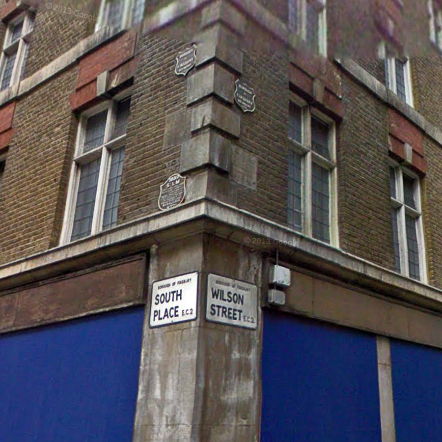 This rare set of five
marks was intact in 2008 when photo taken, but went during comprehensive development that seems
to have started during 2009. The loss of this set of marks is very unfortunate, partly because
it was nice as a set and partly because the metal 1889 St Luke shield appears to have been
unique and now the only indication we have of it seems to be this photograph. The stone marker
is hard to make out, but one can spot the date 1852 and others have concluded the measurement
at the top are the same as on the plate, so it is probably simply an earlier mark for same
parish. There are other marks around the corner, also lost. <Do not get confused by
incorrect attribution to Fulham!> See more detailed images from links below.
This rare set of five
marks was intact in 2008 when photo taken, but went during comprehensive development that seems
to have started during 2009. The loss of this set of marks is very unfortunate, partly because
it was nice as a set and partly because the metal 1889 St Luke shield appears to have been
unique and now the only indication we have of it seems to be this photograph. The stone marker
is hard to make out, but one can spot the date 1852 and others have concluded the measurement
at the top are the same as on the plate, so it is probably simply an earlier mark for same
parish. There are other marks around the corner, also lost. <Do not get confused by
incorrect attribution to Fulham!> See more detailed images from links below.
South Place (St Luke with City of London). No 1.
South Place & Wilson St (St Luke with City of London). No 2.
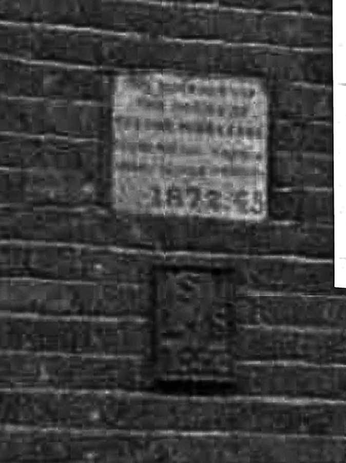
Wilson Street EC2, (corner of South Place)
This mark is part of above set, but around the corner and also lost. As all stone markers are hand
crafted, the loss of any of them is regrettable ; that this one was dated 1810 and survived for some
200 years makes its unnecessary loss little more than shameful. It must be presumed to have been
recovered from an earlier building and refixed on the one recently demolished.
Wilson Street (corner of South Place) (St Luke with St Leonard Shoreditch).
Worship Street EC2, (south side, to west of Wilson Street)
 I have no proper
photograph of these marks beyond that which I have teased out of Google which suggest that a
pair of marks were recovered from old buildings and refixed to this one, presumably during the
1950s judging by the look of the building, which was being demolished before I could record the
markers properly. The boundary ran north-south across the street. The upper mark is stone and
just readable is the date, which looks like 1865. The lower mark looks like a small metal
plate, of similar style to PBM 093 (right), though I cannot make out detail. These are two
different shots but the lower one comes from a source that has compressed part of the image. It
would be great if anyone has proper photos. The location, incidentally, is quite close to the
South Place losses along same boundary. This image (retrieved from Streetview) has been
slightly enhanced but it is the only record I know of.
I have no proper
photograph of these marks beyond that which I have teased out of Google which suggest that a
pair of marks were recovered from old buildings and refixed to this one, presumably during the
1950s judging by the look of the building, which was being demolished before I could record the
markers properly. The boundary ran north-south across the street. The upper mark is stone and
just readable is the date, which looks like 1865. The lower mark looks like a small metal
plate, of similar style to PBM 093 (right), though I cannot make out detail. These are two
different shots but the lower one comes from a source that has compressed part of the image. It
would be great if anyone has proper photos. The location, incidentally, is quite close to the
South Place losses along same boundary. This image (retrieved from Streetview) has been
slightly enhanced but it is the only record I know of.
I did alert Islington Council to the likely loss of these markers early during the demolition process when the facades were intact. They 'hoped' the markers would be restored... A triumph of hope over experience, it seems.
Borough of Spelthorne
Kingston Road, east of Fenton Avenue outside 155.
This stone was by a front boundary hedge that was removed, and sometime after 2012 the stone was
removed altogether or destroyed, presumably to make car parking easier (though it could have been
moved nearby). The stone marked the boundary between Ashford Parish and Staines Parish. With no
inclination by local authorities to give boundary markers any protection, more unfortunate losses
like this are likely.
London Borough of Barnet
Woodhouse Road, N12. North side between Hilton Avenue and Bramber Road, opposite No 156,
in low wall at base of recreation ground railings.
This stone was on pavement in front of recreation ground and follows very old boundary line. In 2015 it was
removed during works to build a new school access road and has not been reinstated, although there is
plenty of space nearby.
The List (2)
I simply list here those I know to have gone in recent years, with as much information as I have. If anyone is aware of others, or if missing markers are known to have been preserved somewhere then I would very much like to know.
London Borough of Camden
155 York Way
These marks seem to have disappeared during 2010 when a small extension was build on south side of
building obscuring wall on which marks were mounted. There is no remaining evidence of their
existence and the assumption must be that they were scrapped. Fortunately neither mark is unique
though this form of St Pancras mark is of a less common type.
155 York Way (St Pancras and Islington).
Kenwood
Along the main carriage drive to the house, from western entrance and car park in Hampstead Lane,
there was, on the north side partly up the vegation-rich cutting, a pair of marks. One was a stone
one for Finchley (my PBM 709) and next to it was a metal Hornsey post (No 303 in Hornsey series).
This was still there when photographed in 2010, but I could not find it when I first looked in 2012
and am now satisfied that it has gone. How a metal post like this can just disappear, with its heavy
below-ground structure, but gone it has. Fortunately there is a rather good image of it here by
Malcolm Edwards.
Kenwood Drive, north side (Finchley Parish with Hornsey Parish).
Kenwood
Along the footpath leading from the dairy to the house, in bushes on the north side, there are some
steps leading up to a couple of seats. Alongside the steps is a metal Hornsey post (No 300 in
Hornsey series and my PBM 301). However there was until recently also a St Pancras Parish stone, No
211 in the St Pancras series and, amazing to say, this substantial stone has disappeared. This was
still there when photographed in 2008 (and is mentioned in Malcolm Stoke's 2010 book on Kenwood
markers), but I could not find it when I first looked in 2012 and am now satisfied that it has gone.
How this could simply vanish after a century and a half defies belied. Fortunately there is a rather
good image of it here on Flickr, by 'Grievous Angel'..
Kenwood west footpath, north side (St Pancras Parish with Hornsey Parish).
London Borough of Hackney
40-41 Newington Green (corner of Albion St)
This mark is known to have been on the building in 2006 when the photograph in the link was taken,
but it seems to have disappeared no later than 2010, probably during building renovation that took
place around that time. It is a huge shame to lose a mark during mere renovation. However, the
saving grace is that this particular mark was not unique and there are other examples nearby.
Newington Green (Stoke Newington Borough with Islington Borough).
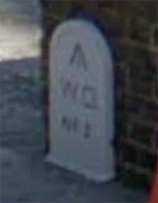
London Borough of Enfield
Whittington Road N22
 It is true that there are quite a lot of apparently identical Wood Green parish
boundary posts dated 1895 but it is still a pity to lose marks that have survived more than a
century. The mark outside 134 Whittington Road was lost or destroyed by builders engaged in
demolishing yet another front garden to make room for a car, and it seems the post was in the
way. No planning application has been found so I dare say the council knew nothing of the post
being removed or (ever the optimist) they may have suggested replacing it against a surviving
wall (as has been done elsewhere). A better image can be found at link below.
It is true that there are quite a lot of apparently identical Wood Green parish
boundary posts dated 1895 but it is still a pity to lose marks that have survived more than a
century. The mark outside 134 Whittington Road was lost or destroyed by builders engaged in
demolishing yet another front garden to make room for a car, and it seems the post was in the
way. No planning application has been found so I dare say the council knew nothing of the post
being removed or (ever the optimist) they may have suggested replacing it against a surviving
wall (as has been done elsewhere). A better image can be found at link below.
Whittington Road Wood Green/Enfield (previously outside No 134).
London Borough of Lambeth
Weir Road SW4
Lambeth has several old parish boundary marker photographs in its collection and the pair here is of
Clapham markers in Weir Road taken in the early 1970s. The parish boundary (unusually) cuts the road
at each end. Using the link below to pull up a 1970s image, two markers appear. I am certain the one
on the left is still in situ and is my PBM508. I had thought the other image was of the 1877 mark
opposite, but close comparison suggests not (the image shows it to be 1875) and it may come from the
east end of the road. If so, it has now disappeared. You can click the image to make it larger.
Weir Road SW4 (Clapham and Streatham).
London Borough of Redbridge
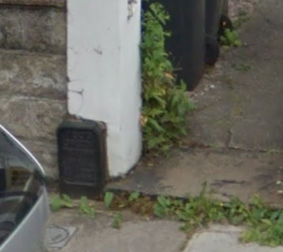
Bush Road E12
Redbridge does not have a huge number of boundary marks and the relatively recent loss of this one
(the plate on left) is unfortunate.
It appears to have been stolen as it could not simply
have fallen off, it had been firmly bolted to the wall.
It was located on the boundary wall of the Friends Meeting House on the south side of the road that also marked the boundary between Leyton and Wanstead parishes. The stone refers to the ownership of the wall and is still there.
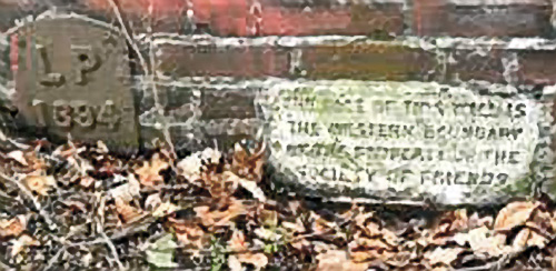
Courtesy of Leytonstone Art & History website, with permission.
London Borough of Tower Hamlets
Tower Hill EC
 The area forming a ring about 100yards wide around the outside of the Tower of
London moat was declared a liberty many hundreds of years ago to support the defence of the
Tower, and its residents were made free of the adjacent City of London. This area has long been
marked by boundary markers installed by the War Department, latterly indicating the property of
the Tower but also the perimeter of the liberty which had parish status of its own.
The area forming a ring about 100yards wide around the outside of the Tower of
London moat was declared a liberty many hundreds of years ago to support the defence of the
Tower, and its residents were made free of the adjacent City of London. This area has long been
marked by boundary markers installed by the War Department, latterly indicating the property of
the Tower but also the perimeter of the liberty which had parish status of its own.
 During the nineteenth century both boundary stones
embedded in walls and free-standing marker posts of a standard design were installed and the
majority of these still survive, the whole lot being listed by English Heritage. Unfortunately
several of these have disappeared during development work, listing notwithstanding. Some have
been replaced by bronze plates embedded in the road surface, but the legality of this
substitution has been queried and an outcome is awaited. Marks 2, 3 and 4 are the ones
affected, the first of these having been a stone and the latter two were posts. The images
above are from Streetview, but better images are available at the links below. The replacement
bronze plates may be found in Set 3 of my inventory numbered PBM675-677.
During the nineteenth century both boundary stones
embedded in walls and free-standing marker posts of a standard design were installed and the
majority of these still survive, the whole lot being listed by English Heritage. Unfortunately
several of these have disappeared during development work, listing notwithstanding. Some have
been replaced by bronze plates embedded in the road surface, but the legality of this
substitution has been queried and an outcome is awaited. Marks 2, 3 and 4 are the ones
affected, the first of these having been a stone and the latter two were posts. The images
above are from Streetview, but better images are available at the links below. The replacement
bronze plates may be found in Set 3 of my inventory numbered PBM675-677.
Tower Hill Mark No 2 (Removed).
Tower Hill Mark No 3 (Removed).
Tower Hill Mark No 4 (Removed).